Spatial Analysis

Filter Courses within "Spatial Analysis" (Click to filter)
Fundamentals of GIS (Coursera) Coursera
University of California, Davis

Fundamentals of GIS (Coursera)

Discover the fundamentals of Geographic Information Systems (GIS) in this engaging online course. Whether you're new to geospatial analysis or looking to enhance your skills, this course will guide you through essential concepts, practical applications, and advanced mapping techniques. Learn how GIS can transform data into actionable insights and create compelling visual representations of spatial information.

Jun 8th 2026
4 Weeks
GIS Data Formats, Design and Quality (Coursera) Coursera
University of California, Davis

GIS Data Formats, Design and Quality (Coursera)

Dive into Geographic Information Systems (GIS) with our 'GIS Data Formats, Design and Quality' course. Learn how to design efficient data tables, manage relational databases, create and manipulate raster data, and build engaging web maps. This comprehensive guide is perfect for those looking to refine their GIS expertise and improve data quality.

Jun 8th 2026
4 Weeks
Introduction aux Systèmes d’Information Géographique - Partie 2 (Coursera) Coursera
École Polytechnique Fédérale de Lausanne

Introduction aux Systèmes d’Information Géographique - Partie 2 (Coursera)

Plongez dans la seconde partie d'un enseignement complet sur les systèmes d’information géographique (SIG). Ce cours introductif est conçu pour vous initier aux concepts clés de SIG sans nécessiter de connaissances préalables en informatique. Apprenez à manipuler des données spatiales et à créer des cartes géographiques avec QGIS, un logiciel libre. Préparez-vous à une expérience pratique enrichissante.

Jun 1st 2026
5-12 Weeks
Spatial Analysis and Satellite Imagery in a GIS (Coursera) Coursera
University of Toronto

Spatial Analysis and Satellite Imagery in a GIS (Coursera)

Discover the power of spatial analysis and satellite imagery in Geographic Information Systems (GIS) with our expert-led online course. Whether you're a student, professional, or enthusiast, this course will equip you with essential skills for analyzing map data, filtering datasets, and uncovering spatial relationships to answer complex geographic questions.

Jun 1st 2026
5-12 Weeks
Introduction to GIS Mapping (Coursera) Coursera
University of Toronto

Introduction to GIS Mapping (Coursera)

Embark on an exciting journey into the realm of Geographic Information Systems (GIS) with this foundational course. Discover how to harness the power of GIS mapping to visualize, analyze, and understand spatial data. Perfect for beginners eager to explore the intersection of geography, technology, and data visualization.

Jun 1st 2026
5-12 Weeks
GIS Data Acquisition and Map Design (Coursera) Coursera
University of Toronto

GIS Data Acquisition and Map Design (Coursera)

Discover how to find and utilize GIS data for creating compelling maps with our 'GIS Data Acquisition and Map Design' course. Whether you're a beginner or an experienced professional, this course will equip you with the skills needed to efficiently acquire, analyze, and present geographic information system (GIS) data effectively.

Jun 1st 2026
5-12 Weeks
GIS, Mapping, and Spatial Analysis Capstone (Coursera) Coursera
University of Toronto

GIS, Mapping, and Spatial Analysis Capstone (Coursera)

Embark on a comprehensive journey through the world of Geographic Information Systems (GIS) with our 'GIS, Mapping, and Spatial Analysis Capstone' course. This final project-based module will challenge you to apply all the skills you've acquired by designing and executing your own GIS project. From proposal writing to data analysis and map creation, this course culminates in the production of an Esri story map that demonstrates your mastery of spatial analysis tools.

Jun 1st 2026
5-12 Weeks
GIS Applications Across Industries (Coursera) Coursera
University of California, Davis

GIS Applications Across Industries (Coursera)

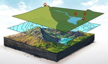
Discover the transformative potential of Geographic Information Systems (GIS) in this specialized online course. Gain practical skills applicable to environmental studies, public health, emergency management, and business development. Master advanced analysis techniques using ArcGIS Pro through hands-on exercises.

May 25th 2026
4 Weeks
Spatial Data Science and Applications (Coursera) Coursera
Yonsei University

Spatial Data Science and Applications (Coursera)

Discover the world of Spatial Data Science, a rapidly growing field that combines geography, statistics, and computer science. This course is designed for data scientists and analysts looking to expand their expertise into spatial analysis and GIS. Learn how to harness the power of location-based data to solve complex problems in various industries.

May 18th 2026
5-12 Weeks
Page 1 Next ›